Shandong Fengtu IOT Technology Co., Ltd
Sales Manager:Ms. Emily Wang
Cel,Whatsapp,Wechat:+86 15898932201
Email:info@fengtutec.com
Add:No. 155 Optoelectronic Industry Accelerator, Gaoxin District, Weifang, Shandong, China


Sales Manager:Ms. Emily Wang
Cel,Whatsapp,Wechat:+86 15898932201
Email:info@fengtutec.com
Add:No. 155 Optoelectronic Industry Accelerator, Gaoxin District, Weifang, Shandong, China
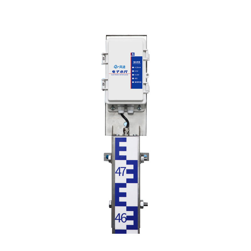
Model:FT-SC24
Brand:fengtu
Water Level Measurement Devices are suitable for water level monitoring in groundwater, rivers, lakes, reservoirs, coasts, etc., and can transmit data by wired or wireless means.
Water Level Measurement Devices : Main unit, water level gauge, collector, power supply system, pole
Working Principle of Water Level Measurement Devices: Utilizing the weak conductivity of water, using advanced processor chips as controllers, acquiring water level data through measuring electrodes, transmitting after CPU digital encoding, division, sampling, and digital processing, and then using wired or wireless communication technology to send water level data to the monitoring center or software, to play the role of real-time water level monitoring and early warning.
Power supply: Solar power supply, 30W, 20AH
Transmission mode: 2G wireless transmission, 4G optional
Installation method: wall mounted
Equipment accuracy 1cm (full range accuracy)
Resolution: 1cm
Unit section specification: 80cm
Measuring length: 80cm*3
Communication interface: RS485 as standard, 4G, 4-20ma, 0-5v, 0-10v as optional
Parameter configuration: Configuration tool configures specific parameters
Working modes: air height mode, water depth measurement mode, tilt measurement mode
Maximum power consumption: host maximum power consumption 1W, water gauge maximum power consumption 0.05W
Control card switch: RS485 has a relay output by default, which can be arbitrarily associated with alarm output or used for water level upper and lower limit control.
Installation hole size: 86.2mm
Mounting hole diameter: 10mm
Drones are capable of accurately measuring wind, and the FT-F1 Anemometer for drones achieves this by utilizing the principle of ultrasonic resonance.Specifically, the instrument emits two fixed-frequency ultrasonic waves in the direction of the wind. Due to the influence of the wind speed, there wi...
Meteorological emergency monitoring is an action that utilizes professional equipment and technologies to collect meteorological data in real-time and dynamically in response to sudden meteorological disasters or abnormal meteorological conditions. Through the rapid monitoring and analysis of meteor...
The efficient operation and safety guarantee of the transportation industry are inseparable from accurate visibility data. In low-visibility weather conditions, such as heavy fog, torrential rain, blizzards, etc., the driver's field of vision will be reduced, increasing the probability of traffi...
During the highway construction process, various types of pollution will be generated, among which PM pollution is particularly prominent. In the operations of earthwork filling and excavation, transportation and mixing of road construction materials, asphalt heating and mixing, paving during the pa...


 Get a Free Quote
 Skype
Skype
 whatsapp
 mail
mail