Shandong Fengtu IOT Technology Co., Ltd
Sales Manager:Ms. Emily Wang
Cel,Whatsapp,Wechat:+86 15898932201
Email:info@fengtutec.com
Add:No. 155 Optoelectronic Industry Accelerator, Gaoxin District, Weifang, Shandong, China


Sales Manager:Ms. Emily Wang
Cel,Whatsapp,Wechat:+86 15898932201
Email:info@fengtutec.com
Add:No. 155 Optoelectronic Industry Accelerator, Gaoxin District, Weifang, Shandong, China
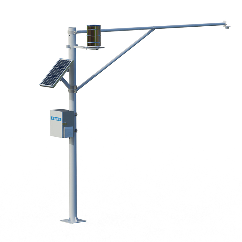
Model:FT-SW2
Brand:fengtu
1.Remote Rain Level Monitoring product overview
SW2 is a fully automatic hydrological online monitoring system based on microwave technology, which can measure water level and rainfall in the channel at the same time.It uses advanced K-band plane radar technology to measure the water level and rainfall of water bodies through non-contact methods, and calculate and output real-time data according to the built-in software algorithm; it can be used for non-contact flow measurement in rivers, irrigation canals, underground drainage pipelines, flood prevention warnings and other occasions; the product has the characteristics of low power consumption, small size, high reliability and convenient maintenance; the measurement process is not affected by factors such as temperature, silt, river pollutants, and floating objects on the water surface.
2.Remote Rain Level Monitoring Application Field
1.Measure water levels and rainfall in rivers, lakes, tides, reservoir gates, groundwater pipelines, irrigation channels, etc.
2.Auxiliary water treatment operations, such as urban water supply, sewage discharge monitoring, etc.
3.Flow calculation, inlet and drainage flow monitoring, etc.
3.Remote Rain Level Monitoring product features
1.Non-contact measurement, calculate flow in combination with cross-sectional parameters, and is not affected by wind, temperature, haze, silt, sand, floating objects, etc.
2.It is suitable for a variety of measurement conditions, and is not affected by corrosion and foam, and can output measurement data of water level and rainfall.
3.The water level uses a flat array radar antenna, with its own angle measurement function, the equipment is small in size and easy to install
4.Convenient configuration software can easily configure parameters according to actual needs to adapt to different usage conditions.
5.Not affected by changes in water vapor, temperature and pressure in the atmosphere
4.Remote Rain Level Monitoring Monitoring Platform
1.CS architecture software platform, supports direct observation of mobile phones and PC browsers without additional software installation.
2.Support multiple accounts and multiple devices to log in
3.Support real-time data display and historical data display dashboard
4.Cloud server and cloud data storage are stable and reliable, easy to scale, and load balancing.
5.Support SMS alarm and threshold settings
6.Support map display and viewing device information.
7.Support data curve analysis
8.Support data export table form
9.Supports data forwarding, HJ-212 protocol, TCP forwarding, http protocol, etc.
10.Support data post-processing function
11.Support external running of javascript scripts
5.Remote Rain Level Monitoring Summary Indicators
Supply voltage: 100mA (operation), <1mA (sleep);
Working voltage: 12V power supply
Operating temperature: -35℃~60℃;
Storage temperature: -40℃~60℃;
Field protection level: IP68
Signal output: RS485/MODBUS protocol;
6.Remote Rain Level Monitoring Technical Parameters
Water level measurement
Range measuring range: 0.1-40 meters
Range measurement accuracy: ±5mm
Range measurement resolution: 1mm
Interval time: 1-5000min
Rainfall monitoring
Measuring range: rain intensity 0~4mm/min
Measuring accuracy: ±0.2mm
Resolution: 0.2mm
Rain diameter: φ200mm
Power supply method: combined power supply of solar panels + battery
Solar power: 10W/30W (optional)
Battery parameters: DC3.7V 10Ah
Support height: vertical pole 3 meters cross arm 3 meters
Working environment: -45℃~85℃ (not freezing state)
7.Precautions for installation of Remote Rain Level Monitoring
1.Installation environment
There are no huge stones in the test channel blocking the water, no huge vortexes, turbulences, etc.
The test channel section should be straight, stable, and concentrated
The test channel section needs to be hardened, and the measurement section should be regular
The test channel section should be kept smooth to prevent floating objects from accumulating
2.Installation height
Recommended installation height 3-4 meters
A Portable Weather Station is a highly integrated, easy-to-carry, and rapidly deployable automated meteorological observation device. It can provide real-time, accurate local meteorological data in areas not covered by traditional fixed weather stations, serving as a "take-anywhere" mini w...
Emergency meteorological monitoring refers to the rapid and accurate monitoring and analysis of relevant meteorological parameters during sudden meteorological disasters or emergency events. Its purpose is to provide timely and reliable meteorological evidence for emergency decision-making, so as to...
Accurate monitoring of road conditions is conducive to ensuring traffic safety and improving road operation efficiency. Traditional road monitoring methods have limitations, and the emergence of Road Condition Monitor has brought us new solutions.One of the major advantages of Road Condition Monitor...
Highway visibility monitoring is a crucial part of ensuring road traffic safety. With the development of mobile Internet technology, the Road Weather Information System has achieved a functional leap from the computer terminal to the mobile phone terminal.The traditional computer - based monitoring...


 Get a Free Quote
 Skype
Skype
 whatsapp
 mail
mail