Shandong Fengtu IOT Technology Co., Ltd
Sales Manager:Ms. Emily Wang
Cel,Whatsapp,Wechat:+86 15898932201
Email:info@fengtutec.com
Add:No. 155 Optoelectronic Industry Accelerator, Gaoxin District, Weifang, Shandong, China


Sales Manager:Ms. Emily Wang
Cel,Whatsapp,Wechat:+86 15898932201
Email:info@fengtutec.com
Add:No. 155 Optoelectronic Industry Accelerator, Gaoxin District, Weifang, Shandong, China
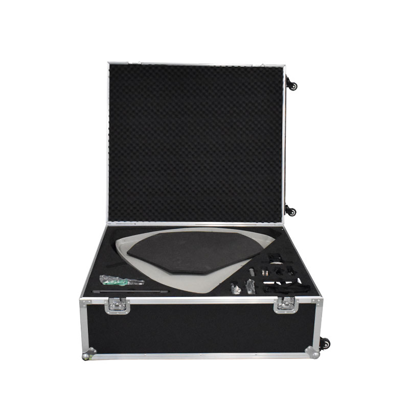
Model:FT-WX1
Brand:fengtu
1.Satellite data collection system equipment introduction
Satellite data collection system is mainly used by individual soldiers to carry out meteorological and hydrological data receiving tasks. It can be used to receive various meteorological and hydrological data such as meteorological drawing reports, real-time reports, fax maps, grid reports, satellite cloud maps, etc. issued by the satellite meteorological and hydrological data broadcasting system. It has the characteristics of easy portability and wide application area.
2. Satellite data collection system product features
1.Stable signal and strong anti-interference ability
2. Easy to load and unload, suitable for rapid field deployment
3. Easy to carry, customized special carrying case
4. Widely used, compatible with multiple satellite signals
5. Quality assurance, testing and certification by authoritative organizations
Satellite reception dedicated high-frequency head, strong anti-interference ability, stable signal, signal quality can reach more than 70%
Portable handheld satellite finder, high sensitivity, compatible with multiple satellite signals, built-in lithium battery, no need to connect to external power supply
Professionally customized portable box, reasonable layout, strong and durable, very suitable for field operations and long-term storage
3. Satellite data collection system technical parameters
| Local Oscillator Type | PLL Phase Locked Loop |
| Local Oscillator Stability | ±15kHz max |
| Input frequency | C band: 3.70~4.20 GHz; |
| Output frequency | L band: 950~1450 MHz; |
| Local Oscillator Frequency | 5.15GHz |
| Gain | 55~62dBm |
| Antenna diameter | 150cm |
| size | 1020mm×920mm×300mm |
| weight | ≤55Kg; |
| Ambient temperature | -40℃~60℃ |
| Ambient humidity | 0~100% |
4. Satellite data collection system configuration list
| Parts Name | quantity |
| Portable Antenna | 1 set |
| High-frequency head | 1 |
| Coaxial Cable | 30 meters |
| Feed plate | 1 |
| Modem Box | 1 unit |
| Star Finder | 1 unit |
| Electric hand drill | 1 |
| Laptop | 1 unit |
| Matching connectors (20 pieces) | 1 set |
| Ground nails | 1 set |
| Instruction manual, certificate of conformity, warranty card | 1 set |
In the field of road traffic, adverse weather conditions are like invisible "traffic killers", posing a huge threat to safe operations. Road surface water accumulation, thick snow, excessive rain and snowfall, or the frequent occurrence of extreme weather such as dense fog, thick fog, sand...
By integrating Beidou-3 short message communication technology with meteorological sensors, Beidou weather stations enable 24-hour unattended monitoring. Data is transmitted back in real-time via satellite links, effectively resolving the challenges of meteorological data collection and transm...
Traditional fixed visibility monitoring equipment is limited by factors such as installation location and power supply conditions, making it difficult to meet flexible and variable monitoring needs. The emergence of the Portable Visibility Detector has effectively solved this problem.Low visibility...
Question 1: What is a survey-grade integrated GNSS?"Survey-grade" means the device is specifically designed for high-precision measurement tasks, capable of achieving positioning accuracy from millimeter to centimeter level. It adopts differential RTK technology, which effectively eliminat...


 Get a Free Quote
 Skype
Skype
 whatsapp
 mail
mail