Shandong Fengtu IOT Technology Co., Ltd
Sales Manager:Ms. Emily Wang
Cel,Whatsapp,Wechat:+86 15898932201
Email:info@fengtutec.com
Add:No. 155 Optoelectronic Industry Accelerator, Gaoxin District, Weifang, Shandong, China


Sales Manager:Ms. Emily Wang
Cel,Whatsapp,Wechat:+86 15898932201
Email:info@fengtutec.com
Add:No. 155 Optoelectronic Industry Accelerator, Gaoxin District, Weifang, Shandong, China
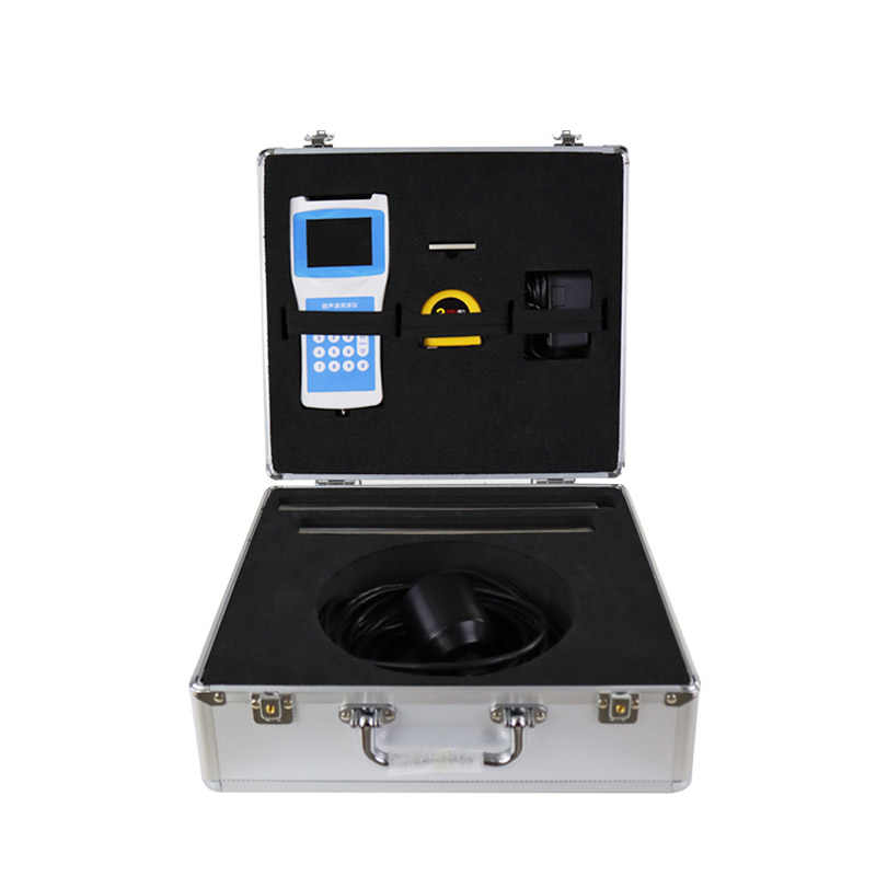
Model:FT-CS50
Brand:fengtu
1.Introduction to Depth Sounder
Depth Sounder is a portable depth sounder for measuring water bodies such as reservoirs, lakes, rivers, shallow seas.When the depth is measured, the ultrasonic transducer is placed on the water surface or a certain position.The fixed sound speed of ultrasonic waves in the water and the time T emitted by ultrasonic waves to the reception time T, and the instrument automatically converts the water depth H.This product is a convenient and suitable handheld ultrasonic distance measuring instrument developed by our company for many years of production experience, absorbing the advantages of many similar products.The ultrasonic transceiver and reception conversion circuit adopts a dedicated large-scale integrated circuit with a component patch rate of 99%, and the depth of the liquid crystal displays, ensuring the long-term reliability of the product and reducing its power consumption to an extremely low level.It has the advantages of accurate measurement, power consumption, high reliability, easy use, simple operation, accurate measurement speed, and easy portability.The instrument can be measured in still water or in water with a certain speed; the water flow rate can reach about 5m/second, making it an ideal water depth measurement instrument for hydrological testing, hydropower plant reservoir area, lakes, river channel surveys and environmental water monitoring.
2.Technical features of Depth Sounder
Medium, small ship is installed outboard (inside) with cables of 10 meters;
Static fixed-point measurement;
Self-stable measurement technology and fast tracking technology, real-time response to real measurement results;
Built-in watchdog circuit to ensure reliable and stable operation for a long time;
Large capacity storage, using USB flash drive to export data;
High-precision clock, annual error of 3PPM;
The FAT32 file system automatically exports and stores it as a CSV format file;
The high-bright screen display is used to display the field measurement data more clearly;
3.Depth Sounder Technical Parameters
| Measurement principle | Ultrasonic measurement method |
| Range range | 0-50 meters |
| Blind area | 0.5 meters |
| power | Transmission power level 32, automatic gain adjustment |
| Minimum display resolution | 0.1mm |
| Accuracy | ±1%×range |
| show | Chinese LCD full color screen display |
| Operating frequency | 200~2000KHz |
| On-site settings: | Completed by sensor key |
| Calibration: | Factory calibration, on-site calibration |
| Output, storage | Export data from USB disk, and the on-board FLASH generates EXCEL files to automatically store the measurement data, with a maximum storage number of 5,000 pieces. |
| Operating voltage: | Built-in battery, external charger |
| keyboard: | Number keys |
| Material: | Host: ABS engineering plastics |
| Sensor: ABS engineering plastic | |
| Test rod: stainless steel, 2 pieces | |
| weight: | Host: 300g |
| Sensor: 650~750g | |
| Sensor cable: | Wire diameter 5~10mm×10m |
| Sensor weight tube: | Length 53cm |
| Temperature measurement range: | -45℃~85℃ |
| Operating temperature: | ≤80%RH without condensation |
| Storage temperature: | ≤80%RH without condensation -40℃~70℃ |
The combination of carbon fiber support and portable design has brought about performance improvements for the Portable Meteorograph. In the field of outdoor meteorological monitoring, the stability, durability, and portability of equipment directly affect the accuracy of monitoring data and operati...
The comprehensive instrument for measuring temperature, humidity and wind speed is Fengtu's handheld weather station, FT-SQ5A, which measures wind speed, wind direction, air temperature, humidity, atmospheric pressure, wind speed, wind direction, altitude (optional) and other elements based on t...
Rain is a natural necessity, but excessive rainfall can bring about serious disasters. Urban waterlogging can lead to traffic paralysis, and floods can submerge streets and houses, posing a threat to life safety. Heavy rainfall in mountainous areas is likely to trigger mountain torrents, landslides...
In modern society, the measurement of visibility is of great significance. In terms of meteorological research, visibility data is a crucial element for analyzing atmospheric characteristics. Its value can reflect the conditions of water vapor and particulate matter in the atmosphere, helping meteor...


 Get a Free Quote
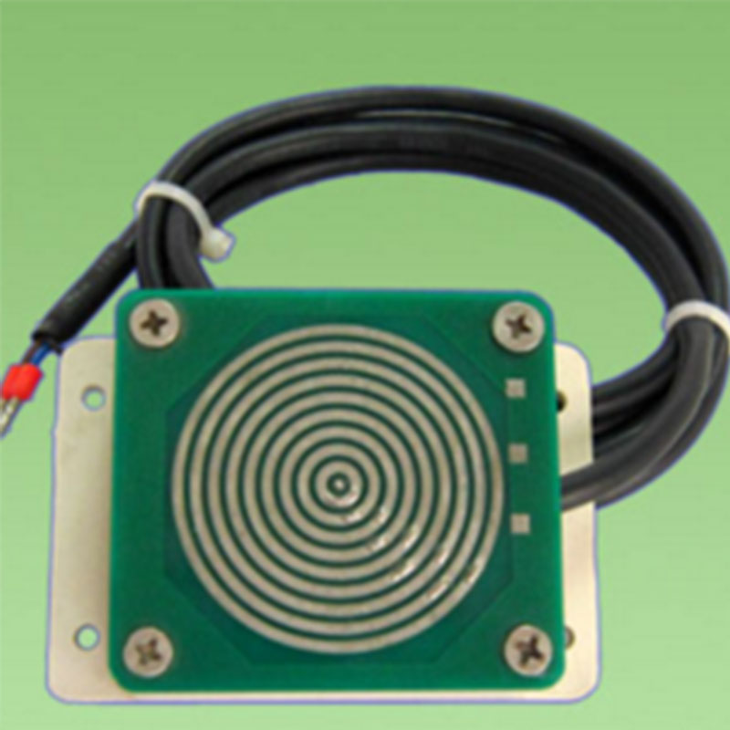
 Skype
Skype
 whatsapp
 mail
mail