Shandong Fengtu IOT Technology Co., Ltd
Sales Manager:Ms. Emily Wang
Cel,Whatsapp,Wechat:+86 15898932201
Email:info@fengtutec.com
Add:No. 155 Optoelectronic Industry Accelerator, Gaoxin District, Weifang, Shandong, China


Sales Manager:Ms. Emily Wang
Cel,Whatsapp,Wechat:+86 15898932201
Email:info@fengtutec.com
Add:No. 155 Optoelectronic Industry Accelerator, Gaoxin District, Weifang, Shandong, China
Model:FT-F1H
Brand:fengtu
1、3D Anemometer for Unmanned Aerial Vehicles Product Introduction
3D Anemometer for Unmanned Aerial Vehicles features a compact design (measuring path of only 35 mm) and a lightweight construction (114 grams). Despite its small size, it is a powerful and highly accurate wind measurement sensor used for atmospheric monitoring, weather reporting, and environmental airflow system research, providing data on wind speed, wind direction, inclination, electronic compass, and BeiDou navigation system.
3D Anemometer for Unmanned Aerial Vehicles provides precise three-dimensional wind measurement data of airflow. Data output can be customized according to user requirements.
The small size and lightweight design of the 3D Anemometer for Unmanned Aerial Vehicles make it a perfect choice for Unmanned Aircraft Systems (UAS). The absence of moving parts eliminates maintenance issues, allowing it to be placed on fixed or mobile platforms for real-time three-dimensional airflow measurements in natural environments.
2、3D Anemometer for Unmanned Aerial Vehicles Application Areas
Atmospheric detection and scientific research
U, V, W vector output
UAV-based high-altitude airflow monitoring system
Emergency rescue and special surface air turbulence monitoring
Monitoring of upward airflow on slopes for weather modification
3、3D Anemometer for Unmanned Aerial Vehicles Technical Parameters
| Wind speed | Measurement range | 0-50m/s |
| Precision | ±2% | |
| Resolution | 0.1m/s | |
| Wind direction | Measurement range (U/V) | 0-359° |
| Measurement range (W) | ±60° | |
| Precision | ±3° | |
| Resolution | 1° | |
| Ultrasonic output frequency | 1Hz (standard output); 2Hz, 5Hz, 10Hz (optional) | |
| Unit of measurement | m/s,knots,mph,kph,ft/min | |
| Digital/analog output interface | RS232/RS485 (one of them) | |
| Communication baud rate | 4800-19200 | |
| Protection level | IP65 | |
| Working temperature | -40℃-+70℃ | |
| Electromagnetic shielding | Meet EN61000-6-2 standard | |
| Power requirements and consumption | DC9-30V (30mA@12V) | |
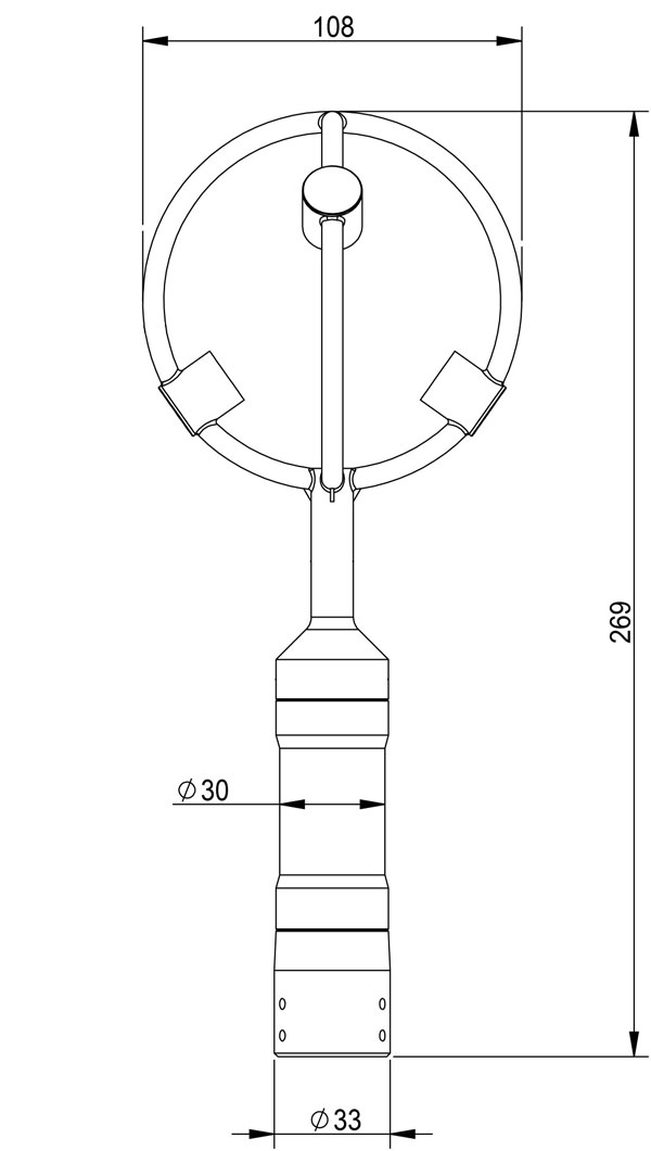
| Dimensions/weight | Φ108×269mm/114g | |
| Materials | Black resin | |
4、3D Anemometer for Unmanned Aerial Vehicles Product dimensions diagram
Crop Growth Monitoring utilizes high-definition video cameras to provide real-time monitoring of crop growth and development, supporting both daytime visual imaging and nighttime infrared imaging. The device integrates meteorological sensors, soil moisture sensors, and pest forecasting lamps t...
Environmental Monitoring Station captures the concentration of negative oxygen ions in the air around the clock, relying on IoT technology to provide data support for environmental health and ecological value....
Lightning Warning System is an atmospheric electric field detection device developed using MEMS technology based on the principle of charge induction; it contains no wear-prone mechanical components, such as motors. The device features a measurement range of -100 kV/m to +100 kV/m and a detect...
The Mechanical weather station is called "fixed" because this type of equipment is usually installed at specific locations, such as meteorological observation fields, airports, ports, high mountains, or remote areas, and will be permanently fixed at that position for meteorological observa...


 Get a Free Quote

 Skype
Skype
 whatsapp
 mail
mail