Shandong Fengtu IOT Technology Co., Ltd
Sales Manager:Ms. Emily Wang
Cel,Whatsapp,Wechat:+86 15898932201
Email:info@fengtutec.com
Add:No. 155 Optoelectronic Industry Accelerator, Gaoxin District, Weifang, Shandong, China


Sales Manager:Ms. Emily Wang
Cel,Whatsapp,Wechat:+86 15898932201
Email:info@fengtutec.com
Add:No. 155 Optoelectronic Industry Accelerator, Gaoxin District, Weifang, Shandong, China
time:2025-03-12 13:11:20 source:Weather Station viewed:522 time
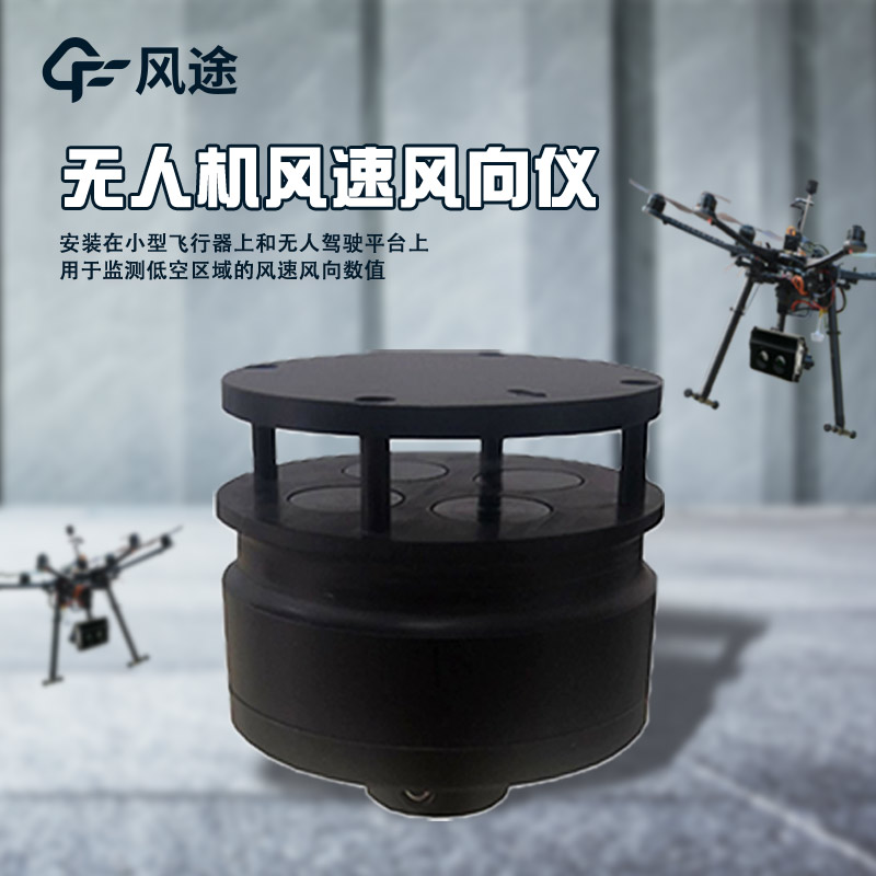
Anemometer for drones is a device installed on unmanned aerial vehicles (UAVs) and is used to measure wind speed and wind direction. It can flexibly and efficiently collect atmospheric data in specific areas or at specific altitudes, and is applicable to fields such as meteorological research, environmental monitoring, and disaster early warning.
Its advantages are mainly reflected in the following three aspects:
Advantage 1: Flexible Deployment
UAVs can quickly reach the designated location for wind speed and wind direction measurement, without being restricted by ground traffic and terrain. Whether it is in mountainous areas, forests, oceans, or complex urban environments, UAVs can quickly reach the measurement area. Compared with traditional fixed meteorological stations, it greatly improves the flexibility of measurement. During the flight, UAVs can obtain wind speed and wind direction data at different locations in real time, and can adjust the flight path at any time according to the preset route or actual situation, and conduct multi-point and multi-altitude measurements in a specific area, so as to obtain more comprehensive and detailed distribution information of meteorological data, which is helpful for a more accurate analysis of meteorological change trends.
Advantage 2: Lower Cost
Compared with the construction and maintenance of traditional meteorological observation towers, mobile meteorological observation vehicles, etc., the cost of equipping UAVs with anemometers is relatively low. There is no need to build fixed infrastructure, reducing the investment of manpower and materials. Especially when it is necessary to temporarily add measurement points or carry out short-term measurement tasks, the cost advantage is more obvious. UAVs can quickly complete measurement tasks and obtain a large amount of wind speed and wind direction data in a short time, improving the measurement efficiency. In addition, UAVs can achieve automated measurement, reducing errors and time consumption caused by manual operation, and can provide more timely data support for meteorological research and meteorological services.
Advantage 3: Diverse Functions
In addition to measuring wind speed and wind direction, UAVs can also be equipped with other meteorological sensors at the same time, such as temperature, humidity, and air pressure sensors, to achieve the synchronous acquisition of multi-dimensional meteorological data. These data are interrelated, which helps to have a more comprehensive understanding of the meteorological situation and provides richer data resources for meteorological research and analysis.
insect suction stands 8.3 meters tall and utilizes aerodynamic suction to draw small migratory insects into a collection tray. A camera captures images every 30 minutes; these images are uploaded to the cloud, where they undergo AI recognition to automatically count the insects. Users can remo...
Power transmission line micrometeorological online monitoring system is an industrial-grade multi-element monitoring system designed for the localized meteorological environment of transmission line corridors. It monitors parameters such as wind speed, wind direction, temperature, humidity, atmospheric pressure, and rainfall in real time, transmitting data wirelessly and providing over-limit warnings to support meteorological disaster prevention for high-voltage transmission lines....
Question 1: What is a survey-grade integrated GNSS?"Survey-grade" means the device is specifically designed for high-precision measurement tasks, capable of achieving positioning accuracy from millimeter to centimeter level. It adopts differential RTK technology, which effectively eliminat...
Chemical plant explosion-proof weather stationModel: FT-FB01Manufacturer: Shandong Fengtu Internet of Things Technology Co., Ltd.Product features: FT-FB01 is a new generation of industrial-grade meteorological observation equipment based on ultrasonic series sensors. It adopts a modular design metho...


 Skype
Skype
 whatsapp
 mail
mail